Why Some Circuits Run Clockwise and Others Do Not
Why some circuits run clockwise depends on inherited roads, terrain, and design choices; learn how to read a layout and see what shaped its direction.
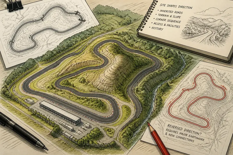
On a circuit map, the start-finish straight points toward a tight right-hand bend, then the track sweeps left across a hillside. That simple change of direction raises a useful question: why some circuits run clockwise while others send cars around the opposite way. The answer usually lies in the land and the design decisions that turned it into a usable course, not in a universal rule about which direction is better.
“Clockwise” describes a lap that turns overall in the same direction as a clock’s hands when viewed from above. It does not mean every corner turns right; any full circuit needs turns in both directions. To understand a track’s direction, look at its origins, its terrain, and the way its layout connects corners and straights.
Start with the site
If a circuit grew from public roads, its direction may simply follow the roads that were available. A route through a park, around a town, or across a former airfield often begins with boundaries and existing pavement that are difficult or costly to rearrange. The chosen lap direction is then a practical fit for that inherited shape.
For a purpose-built venue, the designer has more freedom, but not a blank canvas. A site may have a steep slope, a stream, a ridge, a neighboring road, or a boundary that limits where corners can go. Turning the course clockwise can make one arrangement possible; reversing it may force extra earthmoving, awkward crossings, or a less coherent connection between sections.
Look at a map and note what surrounds the circuit. A long straight pressed against a property edge, a bend that wraps around a hill, or a track that follows a valley may reveal why the layout takes its present direction. These clues are more informative than the visual impression that the circuit simply “leans” one way.
Choose by circuit history
If you are reading a historic road course, begin with its original route rather than asking what a modern designer would choose. Public roads, paths, and old transport facilities can dictate where the track goes. A direction that appears unusual on a clean schematic may make sense when the route is understood as a loop stitched through existing land.
At a permanent circuit, ask whether the current course preserves an earlier layout. Facilities can change over time: corners may be revised, sections added, or the usable course shortened. The direction may remain because the main approach, paddock access, grandstands, and service roads were organized around it. A track’s orientation can therefore outlast the design details that first established it.
Say you are comparing two maps of an invented hillside circuit. The older map shows a clockwise route following a ridge road, while a later proposal reverses the lap and cuts across the slope. The first route would use the existing contour; the second would require a different connection and altered ground. The maps suggest that terrain and infrastructure, rather than a preference for right- or left-hand turns, explain the original direction.
Read the terrain
If a circuit crosses uneven ground, follow its elevation changes. A turn may be placed where the land naturally rises or falls, and the next section may depend on the slope’s shape. Reversing the lap changes which corner comes before a crest, descent, or compression, so it can make the same physical pavement feel like a different sequence.
That does not mean every hill determines direction on its own. Designers weigh how the whole route fits together: where a straight can sit, how corners connect, and whether the course can be built within the site. Terrain is one part of that puzzle, but often a decisive one when the available ground has a strong natural slope.
When looking at a circuit map, use contour lines if they are available, or compare the track with a terrain map. Notice where the route climbs, descends, or crosses a ridge. Then trace the lap in both directions on paper. You may see that one direction produces a natural sequence through the land while the other repeatedly turns against its shape.
Consider the corner sequence
If the site permits more than one direction, the corner sequence becomes a design choice. A circuit is not just a collection of bends; the exit of one corner sets up the approach to the next. Reversing the route changes that relationship. A broad curve may lead into a braking zone one way and become an exit curve the other way.
Designers also consider visibility and the places where cars approach a corner. The shape of a bend, the angle of its entry, and what lies beyond it all affect how the course can be laid out. This is a design and safety matter, not a simple matter of turning the route around. The appropriate arrangement depends on the circuit’s full design and applicable requirements.
Do not infer that clockwise circuits are inherently safer, faster, or more demanding than counterclockwise ones. Direction alone does not tell you how many corners there are, how sharply they turn, or what the elevation changes demand. Those qualities come from the specific layout and its surroundings.
Which explanation fits?
Why do road circuits keep one direction?
A road circuit is often shaped by streets and roads that already form a usable loop. Reversing direction may be possible in theory but impractical if the route, access points, or surrounding infrastructure were arranged for the existing lap.
Can a permanent track run both ways?
Some venues may be able to configure a different route or direction, while others are designed around one intended layout. The pavement is only part of the question; connections, access, sightlines, and the venue’s approved operating arrangements also matter.
Does the hemisphere decide direction?
No. A circuit’s direction is not determined by whether it is north or south of the equator. Its site, existing roads, terrain, and design choices provide the more useful explanation.
Why can’t a circuit simply reverse the lap?
Reversing the direction changes the approach to corners and the order in which elevation changes and straights arrive. It may also conflict with the way the facility is arranged, so a usable reverse layout needs its own design assessment rather than a casual change of direction.
What not to overread
It is not worth trying to assign a single reason to every circuit from a satellite image alone. A bend’s shape can hint at the designer’s choices, but the map may not show old roads, land boundaries, access routes, or later alterations. Treat visual clues as questions to investigate, not proof of a particular origin.
Also avoid reading a track’s direction as a statement of national habit or racing tradition unless there is a clear local history behind it. Two nearby venues can run in opposite directions because their sites and development paths differ. The layout itself is the best starting evidence.
Read the lap in context
To decide what best explains a circuit, sort it by situation: an inherited road course points first to the route already on the ground; a hillside venue invites a close look at contours; a purpose-built circuit on open land makes the corner sequence and facility arrangement more relevant. These are not competing universal rules. They are lenses for identifying the constraints that mattered at a particular place.
So when you next ask why some circuits run clockwise, trace the lap, inspect the land around it, and ask what would change if you reversed it. The clearest explanation is usually not a rule about racing direction but a practical story about how roads, terrain, and design came together at that site.